
-

Hotel Caravan Centre Leh
We offer an experience crafted to provide comfort, luxury, and unforgettable memories
Ladakh Tourist Attactions
Leh - The Capital City
Leh city nestles along the Ladakh range, on the left side of the Indus. It's is a historic town, having been the Royal Capital of the old kingdom since the 15th century, and the Caravan Centre of Central Asian trade. It was the first capital of King Takspa Bum-lde who ruled over the area from 1400 to 1430 AD. He is believed to have built the ‘Red Chapel' containing the 3-storey high statue of the Maitreya Buddha, as well as the Stupa of Ti-siru or Ti'u-Tashis Od-phro containing 108 temples, on the Tiu-Serpo hill.
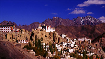
The first recorded fort at Leh was the Namgyal Tsemo castle built by King Tashi Namgyal (1500-1530) on the hill overlooking the town. Of the fort only the ruined remains are found, but the associated temples are intact and maintained by Sankar monastery. The complex comprises the Maitreya Temple and the Gon-khang containing a large image of the 6-armed Mahakala with a protruding phallus, which is superstitiously worshipped by barren women wishing to bear a child. Behind the fort walls, the remains of even more ancient fortifications are seen. These are locally known as Dard Castle (Dok-khar) indicating that there was a castle here even before the establishment of the ruling dynasty of Tibetan origin. On the hill below Namgyal Tsemo is the nine-storied Leh Palace (Lhachen Palkhar) built by King Singge Namgyal in 1600 AD in the grand tradition of Tibetan fort architecture. It is said to have inspired the design of the famous Potala in Lhasa built about half a century later.
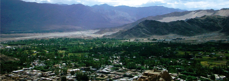
For long a bustling crossroads of the migration & trade routes, Leh is by itself a sightseeing attraction. Strolling along its lanes and by-lanes, observing the varied crowd and looking into the curio shops is an engaging experience. From the head of the main Bazaar begins the old alleyways and piled-up houses of the old town, clustering around the foot of the Palace Hill. The head of the Bazaar is dominated by the Jamia Masjid, which was built during 1666-67 on a land grant offered by King Deldan Nmagyal. The present structure has been built many times and lost the original characteristic although it is much expanded in size. Also located within the main market area is the Jo-Khang commonly known as Gompa Soma (or New Monastery), built in 1957 by the Ladakh Buddhist Association. Behind the main Bazaar, Nau Shehar (formerly called Chang- Gali) has interesting little shops selling curios and jewelry. The old labyrinthine alleyway system around the foot of the Palace Hill, is now partly developed into a road system. In the other direction, down the bazaar, are the Tibetan markets where one can bargain for pearls, turquoise, coral, lapis lazuli and many other kinds of semi-precious stones and jewelry, as well as carved yak-horn boxes, quaint brass locks, china or metal bowls, or any of a whole array of curios. Moti Market is another bustling system of narrow streets & alleyways lined with hundreds of small shops & kiosks. There are many handicraft show rooms in the main market which stock local handicrafts such as handmade carpets, woolen shawls, dragon paintings, thangkas, lacquered tea-tables, etc., all ideal picking as souvenirs.
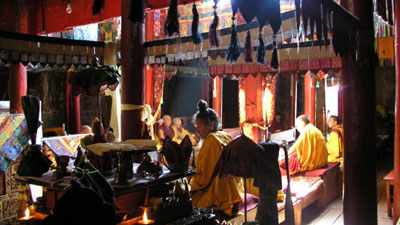
Monasteries
The Buddhist monasteries or Gompa constitute a major cultural attraction of Ladakh. There are nearly 34 major & monasteries in the region out of which the majority are located in the Indus Valley. Out of the many major monasteries as situated on or near the Indus, the most famous from the heritage view point is that of Alchi, called Alchi Choskor (religious conclave), on account of its ancient wall frescoes dating from the 11th and 12th centuries, which pre-date the Tibetan style of paintings and art style seen in all the other Gompas of the region.
Other major monasteries of the Indus Valley are those of Hemis, Chemrey and Stakna - all of which were founded under the direct patronage of members of Ladakh's ruling Namgyal dynasty. Hemis monastery, together with Hanle monastery situated near the Tibetan border, was founded at the instance of King Singge Namgyal, while Chemrey Monastery was established by his queen as a funerary act of merit after his death. All these monasteries belong to the Druk-pa Kragyut school of Tibetan monasticism.
The reformist Gelugs-pa , or Yellow-Hat sect, is also well represented in central Ladakh by the monasteries of Thiksey, Likir, Ri-dzong and Spituk , and the branch monasteries of Stok, Sabu and Sankar. Ri-dzong, situated a few kilometers up a side-valley from Uley-Tokpo , was founded only about a century- and - half ago and is well known for the strict code of living for its monks as envisaged by its founder.. Matho Gompa , nestling along the southern slopes of the Indus valley represents the smaller Saskyapa monastic sect, and is famous for its annual “Festival of the Oracles” which is eagerly awaited by the local people for the predictions of the Matho Oracles about the future course of events in the region.
The other major monastic order of the Druk-pa school, the Drigung-Kargyut sect, is represented by the major monastic foundations of Phyang & Lamayuru. Both these monasteries house sizeable communities of monks. Headed by a common incarnate incumbent or Rimpoche, these monasteries have smaller branches in different parts of Ladakh.
The Ladakh monasteries are repositories of exquisite murals, gilded statues, religious icons, carvings, scrolls etc. built up through the ages. They remain alive with the devotions of monks, young and old. Here it is possible to receive a lama's blessing, consult an astrologer to presage your future, hear the wail of a horn echoing from the mountain walls, and witness a lifestyle passed down intact through the ages. Visiting these monasteries is indeed an uplifting and learning experience.
Note for visitors to monasteries - The monasteries are the fountainhead of Buddhist religion and culture of Ladakh. Visitors are advised to respect their sanctity and appreciate their heritage importance. Shoes may have to be removed before entering some of the temples, while ladies are not allowed to enter the Gon-Khang or the room dedicated to the guardian divinities in many monasteries. Most of the region's major monasteries are open throughout the day and a caretaker Lama (Kom-ngyor) is available to show visitors around. Some of the less visited monasteries have special opening hours as in the case of the Namgyal Tsemo, Shey Palace etc. Check the timings before proceeding to these places.
Forts & Palaces
The section of the Indus Valley from Upshi down to Khalatse, a stretch of about150 kms, is the region's historic heartland as well. It is dotted with all the major sites connected with the former kingdom's history, starting with Leh, the royal capital since the building of the Leh Palace . Some distance upstream the Indus is Shey , Ladakh's most ancient capital, with its palaces and temples. Downstream the Indus are the ruins of the Basgo Fort , located just above the highway, and Tingmosgang, situated a short distance up a side-valley, both served as royal capitals when the Old Kingdom was temporarily divided into two parts during the 15th century. Just across the Indus from Leh is Stok village which was assigned to the deposed royal family in lieu of the loss of the Leh throne to the Dogra conquerors of Ladakh. Stok Palace, where the royal family now lives, houses a museum of artifacts associated with the Namgyal dynasty.
Nubra Valley
Nubra Valley lies to the north of the Indus Valley & Leh, just across the Ladakh range, at an average altitude of 2800 M /10,000 Ft. Popularly called “Ldum-ra” (Valley of Flowers), it nestles sandwiched along the foothills of the Karakoram & Ladakh Ranges and drained by the Siachen & Shayok river system. The valley floor is generally sandy and covered by green oases of the villages and thickets of myricarea. Till closure of the trans-Karakoram trade route by the Chinese in 1949, Nubra was a major trade corridor between Central Asia & Leh and onwards to Srinagar to connect with the Silk Road.
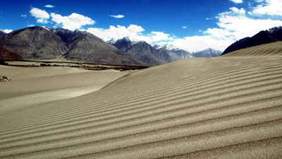
Prominent places in Nubra Valley include Deskit (118 kms), the regional headquarter, dominated by its 15th century hilltop monastery. Just across the rolling sand dunes from Deskit is the pretty village of Hundar (125 kms) which has a small population of double-humped Bactrian camels, a legacy from the Central Asian trade caravans. We can now travel further down river, all the way to the Turtuk-Tyakshi border villages, which are inhabited by ethnic Baltis who harbor & nurture a rich culture of their own.
North of Deskit, the road leads into the valley of the Siachen or Nubra River where the picturesque hillside monastery of Samstaling in the village of Sumur is the main attraction. Samstaling is a branch of the larger Rid-zong monastery in the Indus Valley which is famous for the austere and strict lifestyle of its resident monks. About 25 kms. further up the valley is Panamik, famous for its hot springs which are used as a traditional spa by throngs of local people for curing various ailments to good effect.
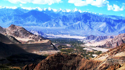
Another attraction of the Nubra visit is the drive across Khardong-la (5602 M / 18,390 ft.), highest motorable road in the world as recorded in the Guinness Book of World records. From the top of the pass one can see all the way south over the Indus Valley to the endless peaks and ridges of the Zanskar range, and north to the gigantic peaks of the Karakoram Range. Khardong-la is strategically important to India as it is used to carry essential supplies to the Siachen Glaciers. Historically, the Khardong-la route played a major role in the Central Asian trade and it is said that about 10,000 horses and camels took it every year.
Dah-Hanou Tribal Area
Down the Indus, between Khalatse and the Shayok-Indus confluence, live a people, known as Drok-pa or Brok-pa, who are Buddhists by faith, but racially and culturally distinct from the rest of the Ladakhis. The road leading down the Indus from Khalatse to connect with Kargil across the4 Humbotingla pass passes through the 5 villages of Biama, Dah, Garkon & Darchiks which are inhabited by the Drokpas. This road follows the Indus, past the villages of Domkhar, Skurbuchan and Achinathang, along a fairly good road.
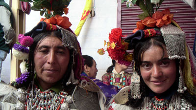
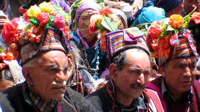
The Drok-pa constitutes a small community of Indo-Aryan people who appear to have preserved their racial purity down the centuries. Their culture and religious practices are more like those of the pre-Buddhist animist religion of the Tibetan Plateau, known as Bon-chos. They have preserved the saga of their ancient traditions and way of life, partly through the celebration of the triennial Bono-na festival, and partly through the songs and hymns, among which the 18 songs of the Bonona festival constitute the core body. Their language is derived from archaic Shina, a language still spoken in Gilgit, and by the Shin immigrants now settled in Drass.
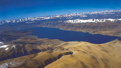
Pangong Lake
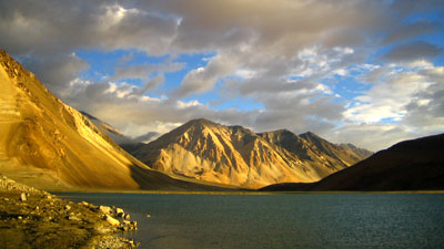
Located at an altitude of 14,500 ft / 4,267 M in the Chang-thang region of Ladakh, Pangong Tso (150 kms) is a long narrow basin of inland water body, about 5-6 kilometers at its widest, and over 140 kms long. One-third of the lake is in India while the rest lies on the Tibet side of the border, where most of the feeder streams are also located. It is the largest brackish water lake in Asia and presents an amazing and captivating sight to behold in its spectacular setting.
The Chang-Chenmo, a range of ochre sandy hills encircling it from the north, provides a spectacular backdrop to the lake's placid water which changes colour from turquoise blue to deep blue, depending upon the condition of the sky. Spangmik and a scattering of other tiny hamlets along the lake's southern shore are the summer homes of the nomadic Chang-pa herdsmen. They cultivate a sparse crop of barley and peas in summer. But in winter they unfold their yak wool tents (rebo), and take the flocks of sheep and pashmina goats to the distant pastures for grazing. One of the few types of birds seen in and around the the lake is the rare Black Necked Crane. seen in and around the the lake is the rare Black Necked Crane.
Tso-Moriri -Tsokar Lakes Circuit
The area traversed by the Manali-Leh road is known as Rupsho. Here, the Zanskar range turns into a landscape quite unlike anywhere else in Ladakh with bare rolling multi-hued hills and high-altitude valleys. Yet the region supports some exotic wildlife such as hordes of Kyang, the wild ass of the Ladakh and Tibet plateau, Tibetan marmots, hares etc. Korzok, situated at 15,000 ft (4,572M) with its dozen or so houses and an ancient gompa, is the only permanent settlement. Otherwise the Rupshu region is inhabited only by nomadic Chang-pa herdsmen, who live in yak-wool tents (rebo) all year round, moving between the pastures that exist wherever streams make growth of grass possible.
The first lake on this circuit is Tsomo-riri. For visiting this lake, drive upstream the Indus, past the hot springs of Chumathang, up to Mahe. Here cross over to the left bank of the Indus and follow the Puga stream through a narrow gorge-like valley upto Puga-Sumdo. From here the straight road leads to Tso-Moriri while the one turning right leads to the Tso Kar area. The road to Tso-Moriri passes over a wide pass with a small brackish water lake at its base. At the end of the drive through some wilderness, suddenly the vast expanse of turquoise blue water of Tsomo-riri appears on the horizon, surrounded all around by mountains. This is a brackish water lake, about 28 km long and 8 km wide, located at an altitude of 15,000 ft / 4,572 m above sea level. It is the breeding ground for numerous species of birds including the bar-headed goose, the great crested grebe, the Brahmini duck and the brown-headed gull
For visiting the other lake in the circuit, retrace the road till Puga Sumdoo after an overnight at Tsomo-riri, and thence follow the left road. At about 4 km from Puga Sumdoo, we reach the wide base of a valley which turns into a green carpet of grass, with hot water shot out of sulphur springs like geysers. At an hours' drive from here is Polo-Kongkha Pass (about 16,500 ft /5,030 M), a long wide tabletop, at the base of which one can have the first glimpse of Tso Kar or “White Lake”. This is a small lake of deep blue water with a chain of snow peaked mountains as the backdrop. The lake produces salt deposits all around its shores which are collected by the nomads and sold all over Ladakh. The nomad settlement of Samad Rokchen is located next to the lake.
Other Attractions
Shanti Stupa - The Shanti Stupa is a magnificent landmark perched on a hill overlooking the Leh valley. It was built in 1991 by the Japanese Buddhist Bhikshu Nakamura. The Stupa holds the relics of the Buddha in its base, enshrined by the 14th Dalai Lama himself. The stupa has become a major tourist attraction not only due to its religious significance but also due to its location which provides panoramic views of the surrounding landscape. Hall Of Fame
The Hall of Fame (War museum) at Leh showcases a narrative on the rich cultural heritage of Ladakh as well as the sacrifice made by Indian soldiers over the past two decades in the defense of the borders and brings together the varied worlds that co-exist in Leh under one small roof. The facade of the museum gives it an appearance of a stupa from afar, the museum is geometrically shaped with sharp definitions. Divided into different sections, one part of the museum showcases the vibrant cultural and natural heritage of Ladakh. On display is the information on the flora and fauna of Leh as well as its people- the lives they lead, rituals they observe and festivals they celebrate. Historical information on the various monarchs of Leh, battles they fought, is also on display. Upper floor is where the military ammunition used by the Indian army in its various battles with Pakistan are on display.
Magnetic Hill - Magnetic Hill is a gravity hill located on the national highway at about 30 kms west of Leh. This hill is renowned for the magnetic effect which pulls vehicles uphill against natural gravity, with the engines turned off.
The spot is well marked by a prominent bill board and a white square drawn in the middle of the road. For experiencing the phenomenon of the magnetic hill the vehicle has to be placed on the marked spot in the middle of the road with the engine switched off. One can notice the vehicle moving up the inclined road at a noticeable speed. Even helicopters flying over the area are said to register this magnetic impact.
Gurudwara Pathar Sahib - Gurudwara Pathar Sahib is located a few kilometers from the “Magnetic Hill”. The Gurudwara is built around a big boulder which has the imprint of a human back and head. Legend has it that during 1515-1518 AD, when Guru Nanak was returning to Punjab through Srinagar, after travelling to Tibet, he rested at this place and meditated. A demon residing in the nearby hill was angered by his presence and threw a large rock at the Guru which hit the back of the meditating Guru and stopped there. Nothing happened to the Guru but the shape of his body got imprinted on the boulder. Seeing this, the demon felt ashamed and apologized to the Guru by prostrating at the feet.
The place remained unexplored even after the boulder was discovered during the construction of the road in the 1970's. The road workers had tried to remove the boulder from the work site but could not do so even with bulldozers. In the meanwhile some locals were seen worshipping the impression of a human back & head on this the boulder. Upon enquiry it was reported that the impression was that of the Guru Rimpoche. Guru Rimpoche was taken to be referring to Guru Nanak and the Gurudwara evolved around this boulder in the course of time. Now it is the focus of attention and reverence of hundreds of visitors and devotees every day.
Khardong-La (alt: 18,390 ft. / 5602 M) - Khardongla is the highest motorable pass and is mentioned in the Guinness Book of World Records. Located in the Ladakh Range of the Himalayas, Khardongla is the main access to the Nubra Valley, and is of strategic importance as it provides access to the Siachen Glaciers .and other strategic locations on the borders. The pass provides panoramic views of the endless peaks & ridges of the Zanskar range across the Indus Valley in the south, and those of the Saser massif in the north. Khardong-la is strategically important to India as it is used to carry essential supplies to the Siachen Glaciers. Historically, the Khardong-la route played a major role in the Central Asian trade and it is said that about 10,000 horses and camels took it every year. It is now a popular half-day excursion destination form Leh.
|
Connect with US
hotel caravan centre
Member Copyright © Hotel Caravan Centre
|

